The Inca complex at Pisac is a large Incan complex of agricultural terraces,
residences, guard posts, watchtowers and a ceremonial/religious center located
along a mountain ridge above the modern town of Pisac in the Sacred Valley of
Peru.
Located at the entrance to the Sacred Valley the Incan complex stretches at
varying elevations between 3,446 m (11,306 ft) and 3,514 m (11,529 ft) above
sea level for approximately 1 km (0,6 mi) along a mountain ridge sandwiched
between the Kitamayu River (to the west) and the Chongo River (to the east),
which are tributaries of the Vilcanota.
|
Pisac Archaeological Park seen from the Taray Viewpoint
The Taray Viewpoint is on the Cuzco - Pisac road.
|
|
Pisac Archaeological Park seen from the Pisac Viewpoint
The Pisac Viewpoint is on the Pisac - Pisac Archaeological Park road.
|
|
Entrance to the Pisac Archaeological Park
After passing through the stalls selling handicrafts, we enter the Pisac
Archaeological Park.
|
|
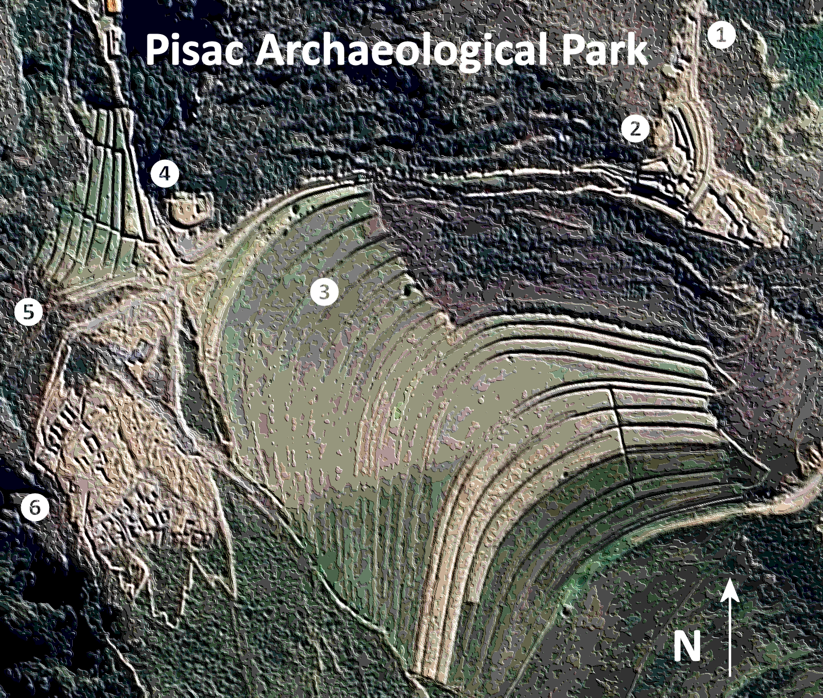
Pisac Archaeological Park Plan
Plan Legend:
- Parking lot
- Urban zone (Qantus Raccay)
- Monumental terraces
- Ceremonial fountains
- Inca cemetery (Tantana Marka)
- Citadel (Qallaq'asa)
|
|
Urban zone (Qantus Raccay)
Located 3,446 m (11,306 ft) above sea level on the edge of a precipice
Qantus Raqay (from the Quechua words qanchus (seven) and
raqay (enclosure)) is also known as "Kanturaqay" (Plan No. 2).
-
One of three residential areas in the complex and spreading over three
levels it consists of rough stone buildings with pirka type walls made
with non-carved mud bonded small and medium-sized stones.
-
The walls were originally had a clay stucco applied overtop,
indicating that they were probably inhabited by those of a
lower-status.
-
From its position overlooking the road toward the Paucartambo region
and the Antisuyo and controlling the northeastern corner of the
complex it probably served as the home of the military garrison or as
a shelter for local villagers in times of war.
|
|
Panorama of the monumental terraces seen from the northeast.
The monumental terraces (Plan No. 3) can be seen here in the urban zone
(Qantus Raccay).
-
The mountain spur is covered with approximately 500 agricultural
terraces called andenes, some 6 metres (20 ft) high in places,
which follow the contours of the hillside.
-
While they reduced the threat of soil erosion from landslides their
primary purpose was to expand the amount of arable land.
-
The terraces are contained by walls of field stones roughly to fit one
another, typically 6 to 7,5 cm (23 to 30 inches) thick.
|
|
Citadel seen from the northeast
The citadel (Qallaq'asa) is located to the west of the monumental
terraces (Plan No. 3).
|
|
Monumental terraces seen from the north
At the bottom of the valley we can see the Urubamba River and the
village of Pisac.
|
|
Panorama of the cemetery (left) and ceremonial fountains (right).
The Inca cemetery (Tantana Marka) is separated from the ceremonial
fountains (Plan No. 4) by the Kitamayo stream.
|
|
Ceremonial fountains (Plan No. 4)
The complex has at least five water supply channels, more two irrigation
channels, more three agricultural drainage channels, but no domestic
wastewater drainage.
-
Water is collected from a small lake 4,500 m (14,800 ft) above sea
level and conveyed via a canal to four purification baths near the
river on the flat area between the Qanchus Racay and Qallaq'asa before
passing along another canal to supply the Qanchus Racay area.
|
|
Inca cemetery (Tantana Marka)
Opposite the Inca baths on the other side of the gully down which the
Kitamayu River flows are tombs cut into the steep cliff face of the
adjacent mountain (Plan No. 5).
-
This was one of the largest cemeteries in the pre-Columbian world,
with more than 3,500 tombs in various states of destruction, though
some sources claim as many as 10,000 tombs.
-
Its name comes from tankay (to push) and marka (place),
which can be translated as launch site.
-
The Incas believed in reincarnation, so they kept their mummies buried
in the fetal position with all their belongings and food needed for
their new life.
-
After the arrival of the Spaniards, huaqueros (grave robbers)
did not hesitate to desecrate the graves and plunder the jewels,
metals and precious stones. Today only small holes remain as a result
of the desecration.
|
|
Citadel (Qallaq'asa)
The name of the Qallaq'asa residential area (Plan No. 6) which is 3,514
m (11,529 ft) above sea level comes from the Quechua words
q'alla (cut) and q'asa (pass), in reference to a tunnel
that connects it with the Intiwatana.
-
Cascading down the side of the hill its 23 buildings are built from
rough field stone, stuck together with adobe, indicating that they
were probably inhabited by lower-status workers.
|
|
Structures protected with roofs
Some structures are protected with roofs to protect the walls.
|
|
Climbing to the top of the citadel
|
|
Entering a section of the citadel with two large niches
|
|
Ceremonial fountains seen from the citadel
|
See also
Source
Location