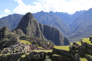
Machu Picchu is a 15th-century Inca citadel located in the Eastern Cordillera
of southern Peru on a 2,430 m (7,970 ft) mountain ridge.
Often referred to as the "Lost City of the Incas", it is the most familiar
icon of the Inca Empire.
Machu Picchu was built in the classical Inca style, with polished dry-stone
walls.
Its three primary structures are the Temple of the Sun, the Temple of the
Three Windows, and the Intihuatana.
|
Machu Picchu Plan
Plan Legend:
- Main entrance
- To Machu Picchu Mountain
- "Qolqas" Storage
- To Sun Gate
- To Inca bridge
- Photographic zone
- Guard House
- Funerary stone
- East agricultural sector
- Main gate
- Temple of the Three Windows
- Intiwatana
- To Huayna Picchu
- Temple of the Sun or Torreón
- Main square
- Cerimonial rock
- Group of the Three Doorways
- Temple of the Condor
|
|
Panorama of Machu Picchu Mountain
Machu Picchu lies 80 kilometers (50 miles) northwest of Cusco, on the
crest of the mountain Machu Picchu (Plan No. 2), located about 2,430
meters (7,970 feet) above mean sea level, over 1,000 meters (3,300 ft)
lower than Cusco, which has an elevation of 3,400 meters (11,200 ft).
- As such, it had a milder climate than the Inca capital.
-
It is one of the most important archaeological sites in South America,
one of the most visited tourist attractions in Latin America and the
most visited in Peru.
|
|
Panorama of the "Qolqas" Storage (left) and Huayna Picchu mountain
(center).
The site is roughly divided into an urban sector and an agricultural
sector, and into an upper town and a lower town.
-
The temples are in the upper town, the warehouses (Plan No. 3) in the
lower.
|
|
Fork in the climbing stairs
-
To the left we go to the upper platform and to Machu Picchu Mountain.
- To the right we go to the lower platform.
|
|
Path to the Sun Gate
Two high-altitude routes from Machu Picchu cross the mountains back to
Cusco, one through the Sun Gate (Plan No. 4), and the other across the
Inca bridge.
-
Both could be blocked easily, should invaders approach along them.
|
|
Path to Machu Picchu Mountain (Plan No. 2)
|
|
Photographic zone (center, Plan No. 6) and Huayna Picchu Mountain
(right, Plan No. 13).
|
|
Panorama from the path to the Inca bridge
In this photo we can see Machu Picchu (left), the Guard's house (Plan
No. 7) and the Funerary stone (center, Plan No. 8) and the East
agricultural sector (right, Plan No. 9).
-
The Inca bridge, an Inca grass rope bridge, across the Urubamba River
in the Pongo de Mainique, provided a secret entrance for the Inca
army.
-
Another Inca bridge (Plan No. 5) was built to the west of Machu
Picchu, the tree-trunk bridge, at a location where a gap occurs in the
cliff that measures 6 meters (20 ft).
|
|
Machu Picchu seen from the path to the Inca bridge (Plan No. 5).
View from southeast to northwest.
|
|
Photographic zone (Plan No. 6)
|
|
Guard's house
The Guardhouse (Plan No. 7) is a three-sided building, with one of its
long sides opening onto the Terrace of the Ceremonial Rock.
-
The three-sided style of Inca architecture is known as the
wayrona style.
|
|
Panorama of Machu Picchu from the Photographic zone (Plan No. 6).
In this photo we can see Machu Picchu (left), the Guard's house (center
left, Plan No. 7) and the Funerary stone (center right, Plan No. 8) and
the East agricultural sector (right, Plan No. 9).
|
|
Panorama of Machu Picchu seen from the Guardhouse (Plan No. 7).
In this photo we see Machu Picchu (left), the East agricultural sector
(center, Plan No. 9) and the guard's house (right, Plan No. 7).
|
|
Machu Picchu seen from the Guardhouse (Plan No. 7)
The architecture is adapted to the mountains.
-
Approximately 200 buildings are arranged on wide parallel terraces
around an east–west central square.
-
The various compounds, called kanchas, are long and narrow in
order to exploit the terrain.
|
|
Panorama of Machu Picchu (left) and the East agricultural sector
(right, Plan No. 9).
Much of the farming done at Machu Picchu was done on its hundreds of
man-made terraces.
-
These terraces were a work of considerable engineering, built to
ensure good drainage and soil fertility while also protecting the
mountain itself from erosion and landslides.
-
However, the terraces were not perfect, as studies of the land show
that there were landslides that happened during the construction of
Machu Picchu.
-
Still visible are places where the terraces were shifted by landslides
and then stabilized by the Inca as they continued to build around the
area.
-
Terraces constructed overlooking the Urubamba River and many other
springs provided fresh water for crop production and served more than
1,000 households.
|
|
Panorama of the East agricultural sector (Plan No. 9)
Terrace farming area makes up only about 4.9 ha (12 acres) of land, and
a study of the soil around the terraces showed that what was grown there
was mostly corn and potatoes, which was not enough to support the 750+
people living at Machu Picchu.
-
This explains why studies done on the food that the Inca ate at Machu
Picchu suggest it was imported from the surrounding valleys and
farther afield.
-
It is estimated that the area around the site has received more than
1,800 mm (71 in) of rain per year since AD 1450, which was more than
that needed to support crop growth. Because of the ample rainfall at
Machu Picchu, it was found that irrigation was not usually needed for
the terraces. The terraces received so much rain that they were built
by Incan engineers specifically to allow for ample drainage of excess
water.
|
|
Houses and small cave after the main gate
Stone stairways set in the walls allowed access to the different levels
across the site.
|
|
Huayna Picchu mountain (top), Intiwatana (center) and Temple of the
Three Windows (bottom).
This photo shows the Huayna Picchu mountain (top, Plan No. 13),
Intiwatana (center, Plan No. 12) and Temple of the Three Windows
(bottom, Plan No. 11).
-
The Intihuatana stone is one of many ritual stones in South America.
These stones are arranged to point directly at the Sun during the
winter solstice.
-
The name of the stone (perhaps coined by Bingham) derives from Quechua
language: inti means "sun", and wata-, "to tie, hitch
(up)". The suffix -na derives nouns for tools or places. Hence
Intihuatana is literally an instrument or place to "tie up the sun",
often expressed in English as "The Hitching Post of the Sun". The Inca
believed the stone held the Sun in its place along its annual path in
the sky.
-
See more at
Intihuatana, Urubamba - Wikipedia.
|
|
Small cave next to the Temple of the Three Windows (Plan No. 11).
|
|
Temple of the Sun or Torreón (Plan No. 14)
This semicircular temple is built on the same rock overlying Bingham's
"Royal Mausoleum", and is similar to the Temple of the Sun found in
Cusco and the Temple of the Sun found in Pisac, in having what Bingham
described as a "parabolic enclosure wall". The stonework is of
ashlar quality.
-
Within the temple is a 1.2 m (3.9 ft) by 2.7 m (12.1 ft) rock
platform, smooth on top except for a small platform on its southwest
quadrant.
-
A "Serpent's Door" faces 340°, or just west of north, opening onto a
series of 16 pools, and affording a view of Huayna Picchu.
-
The temple also has two trapezoidal windows, one facing 65°, called
the "Solstice Window", and the other facing 132°, called the "Qullqa
Window".
|
|
Panorama of the north wall of the Temple of the Three Windows (Plan
No. 11).
|
|
Panorama of the east wall of the Temple of the Three Windows (Plan
No. 11).
The three windows (center) overlook the Main Square (Plan No. 15).
|
|
Panorama of the north wall of the Temple of the Three Windows (Plan
No. 11).
|
|
Panorama of the Guardhouse (Plan No. 7) seen from Machu Picchu.
|
|
Walking through the Main Square (Plan No. 15)
|
|
Panorama of the Main Square (Plan No. 15)
View from north to south.
|
|
Houses next to the Ceremonial rock (Plan No. 16)
|
|
Cerimonial rock (Plan No. 16)
This is the name given to a flat-faced stone placed on a wide pedestal.
-
It is a landmark that marks the northern end of the city and is the
starting point of the road to Huayna Picchu (Plan No. 13).
|
|
Huayna Picchu (Plan No. 13)
A study published in 2021 in Ñawpa Pacha: Journal of the Institute of
Andean Studies suggests that, in the Quechua language, the abandoned
Inca site was called "Huayna Picchu", after the smaller peak at the
site, or perhaps, just "Picchu". Huayna means "young" in the Quechua
language.
-
The research documents that, starting in 1911 with the publications of
American historian and explorer Hiram Bingham, the name Machu Picchu
became associated with the ruins.
|
|
Going through the Group of the Three Doorways (Plan No. 17).
|
|
Temple of the Three Windows (Plan No. 11) seen from the Group of the
Three Doorways (Plan No. 17).
View from east to west.
|
|
Panorama of the East agricultural sector (Plan No. 9)
In this panorama we can see the "Qolqas" Storage (Plan No. 3) on the
left, the Guard House (Plan No. 7) in the center, and the Temple of the
Sun (Plan No. 14) on the right.
|
|
Temple of the Condor (Plan No. 18)
Little information describes human sacrifices at Machu Picchu, though
many sacrifices were never given a proper burial, and their skeletal
remains succumbed to the elements. However, there is evidence that
retainers were sacrificed to accompany a deceased noble in the
afterlife.
-
Animal, liquid and dirt sacrifices to the gods were more common and
were made at the Altar of the Condor.
|
|
Temple of the Sun (Plan No. 14) seen from the Temple of the Condor
(Plan No. 18).
View from northeast to southwest.
|
|
Water sources
Heavy rainfall required terraces and stone chips to drain rain water and
prevent mudslides, landslides, erosion, and flooding.
-
Terraces were layered with stone chips, sand, dirt, and topsoil, to
absorb water and prevent it from running down the mountain.
- Similar layering protected the large city center from flooding.
-
Multiple canals and reserves throughout the city provided water that
could be supplied to the terraces for irrigation and to prevent
erosion and flooding.
|
|
Small cave in the area of the Temple of the Condor and the water
sources.
|
|
Group of the Three Doorways (Plan No. 17) seen from the East
agricultural sector (Plan No. 9).
View from southeast to northwest.
|
|
Panorama of the eastern slope of Machu Picchu
|
|
Machu Picchu Hiking Trail
The classic Inca Trail Route is 43 km (26 mi) long and often steep, you
will hike over four days at an elevation nearing 13,828 feet (4,215
meters).
-
Although rated moderate, the relentless uphill (and downhill) hiking
is tough.
|
See also
Source
Location


