Viracochapampa, Huiracochapampa, or Wiracochapampa (possibly from Quechua
wiraqucha: mister, sir, gentleman, god; or Wiracocha: one of the
greatest Andean divinities; and pampa: plain) is an archaeological site
with the remains of a building complex of ancient Peru of pre-Inca times.
Viracochapampa is located about 3.5 km (2.2 mi) north of Huamachuco in the
region of La Libertad at an elevation of 3,070 metres (10,072 ft).
It was one of the administrative centers of the Wari culture.
|
Prior considerations for visitors
The site was occupied from the late Middle Horizon 1B time to the first
decades of period 2A, according to the chronology established by Dorothy
Menzel, taking as reference the classic division of Horizons and
Intermediate by John Rowe.
- These correspond to the 7th and 8th centuries of our era.
|
|
Plan of Viracochapampa
Plan Legend:
- Entrance
- Courtyard
- Southern hall with niches
- Plaza
- Northern hall with niches
- Drainage system
- Complex hall with niches
- Residential complexes
|
|
Wiracochapampa complex (Plan No. 1)
The Wiracochapampa complex, of typical Huari construction, occupies a
quadrangle of 583 by 566 meters (1913 by 1857 ft), and just under 30% of
its surface was occupied by buildings in different stages of
construction.
-
It comprises eight large groups of unworked stone constructions with
red clay mortar, arranged around a plaza. A square-shaped wall
enclosed the complex. Some of the walls rise more than 5 meters (16
ft) but most have already fallen. These walls were built using two
parallel walls, whose interior space was filled; the upper part has
overhangs that are presumed to have served to support the roofs.
-
The entrance to the complex was both from the north and the south,
leading to a street 565 meters (1854 ft) long and 5 meters (16 ft)
wide that divided the walled complex from end to end in a straight
line. Inside the complex there are also vestiges of aqueducts.
-
It is considered that as a ritualistic center it was the seat of the
governmental and priestly class, with their respective servants or
workers, not being a city in the western sense of the term, since the
bulk of the population lived in the surrounding fields.
|
|
The tour
The tour is 1000 meters (0.6 mi) long and lasts approximately 50
minutes, during which we will be able to see the area with the greatest
concentration of architecture, including the main square.
|
|
Interpretive tour of Viracochapampa
|
|
Panorama of the Courtyard (Plan No. 2)
Notice the main road of Viracochapampa on the left side of the panorama.
-
The main street of Viracochapampa divides the site into two unequal
sides.
- It is 5 m (16 ft) wide and 564 m (1818 ft) long.
-
It joins a very old road that connected to the north with some
villages in the Condebamba valley and, to the south, with those in the
current province of Santiago de Chuco.
|
|
Urban Architecture
Each highlighted set of different colors is surrounded by four walls
that form a courtyard within which other walls were raised to create
galleries, halls with niches, storage rooms and/or corridors.
- It also has different architecture arranged in different ways.
|
|
The control at the entrance
Recreation of the control at the entrance to the main street of
Viracochapampa.
|
|
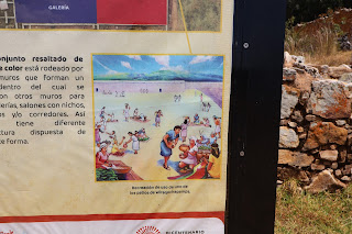
The use of one of the courtyards
Recreation of the use of one of the courtyards of Viracochapampa.
|
|
Walking towards the Southern hall with niches
|
|
Panorama of the Southern hall with niches (Plan No. 3)
|
|
The Plaza (Plan No. 4)
-
What are its dimensions? It measures 93 m (305 ft) long by 72 m (236
ft) wide, roughly the size of a soccer field.
-
Where is it located? It is located in the central part and is the
largest space in Wiraqochapampa.
-
How is it oriented? Its platform is oriented in the direction of the
funerary towers of Marcahuamachuco.
|
|
Features of the Main Plaza
|
|
The ceremonies
In their ceremonies they sacrificed guinea pigs and offered their blood
to the gods.
-
The chiefs or curacas ate and drank, pouring a little chicha on the
ground, worshipping Ataguju and the Chucomama (Mother earth).
|
|
The Northern hall with niches (Plan No. 5)
Relationship of the religion and rites of Peru made by the Augustinian
Fathers (16th century):
-
"…and they slaughtered sheep and threw the blood of the stick, and ate
the meat that there was nothing left over and from there they had to
get anything for the leftovers, there were many little boxes in the
walls to keep the relics that remained from the sheep or cármora, and
the earth is full of these corrals and we destroyed many…"
|
|
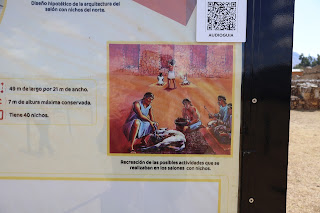
Activities that took place in the rooms with niches
Recreation of the possible activities that took place in the rooms with
niches.
|
|
Panorama of the Northern hall with niches
|
|
Important findings (Plan No. 6)
Inside one of the perimeter walls, the incomplete human remains of three
people were found.
-
Why were they buried in the walls? As guardians, so that their souls
would look after the buildings.
-
Why were the bodies incomplete? Probably so that the souls would
always remain fulfilling their function as guardians.
-
What offerings did they have? One of them had metal ear rings and a
polished black stone ornament.
|
|
Placing dismembered bodies on the walls
Recreation of the process of placing dismembered bodies on the walls.
|
|
Drainage system
Engineers planned a drainage system to prevent the city from flooding
during rain. However, it was left unfinished and never worked or only
partially worked.
-
This system was made up of underground and surface channels or canals
built from slabs and circular structures as water collectors.
|
|
The complex hall with niches (Plan No. 7)
It is a unique case of a hall with niches that has three divisions.
-
There is a main entrance facing east and a secondary entrance that
allows communication with the square through two corridors.
|
|
The complex hall with niches
Hypothetical recreation of the complex hall with niches.
|
|
Panorama of the complex hall with niches
|
|
Residential complexes (Plan No. 8)
Each room with niches was intended to be used by a community united by
kinship ties.
-
The galleries were multi-family spaces made up of living quarters and
domestic activity areas.
|
|
Materials and construction process
-
What was the construction process like? To build the highest walls,
the builders raised them in sections or horizontal panels.
-
What materials did they use? Mud and stone that was brought from the
quarries located in the surrounding hills.
|
|
Hall with niches and gallery
Recreation of a hall with niches and a gallery.
|
|
Construction of the foundations
Recreation of the construction of the foundations of the walls.
|
|
Panorama of the Residential complexes
|
See also
Source
Location


