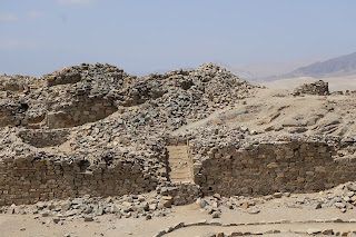
Chankillo or Chanquillo is an ancient monumental complex in the Peruvian
coastal desert, found in the Casma-Sechin basin in the Ancash Department of
Peru.
The ruins include the hilltop Chankillo fort, the nearby Thirteen Towers solar
observatory, and residential and gathering areas.
The site covers about four square kilometres (1.5 square miles) and has been
interpreted as a fortified temple.
The Thirteen Towers have been interpreted as an astronomical observatory built
in the third century BCE.
The culture that produced Chankillo is called the Casma/Sechin culture or the
Sechin Complex.
|
Chankillo Plan
Plan 1 Legend:
- Fortified temple
- Thirteen towers
|
|
Road sign indicating the location of Chankillo
The archaeological site is located at km 361 (mi 224) of the
Panamericana Norte, on the left bank of the Casma River south of the San
Rafael Valley, in Peru.
-
It is located in the district and province of Casma in the Ancash
region of Peru.
-
Chankillo is also located 200 km (124 mi) from Caral, the oldest
civilization on the American continent.
|
|
Walking along the dirt path (Plan 2 No. 1)
From the paved road to the archaeological site it is 3 km (2 mi) of
unpaved road.
|
Fortified temple
|
Fortified temple Plan
Plan 2 Legend:
- Unpaved road
- Guard's house
- Entrance of the first wall
- First wall
- Tunnel of the second wall
- Second wall
- Third wall
- Entrance of the third wall
- North circular building
- South circular building
- Rectangular building
- Thirteen towers viewpoint
|
|
Aerial view of the fortified temple
Museo Regional de Casma "Max Uhle".
|
|
Panorama of Chankillo and its surroundings
|
|
Entrance to the fortified temple (Plan 2 No. 3)
|
|
Climbing the first wall (Plan 2 No. 4)
|
|
Descending from the first wall
The second wall is in front of us.
|
|
Tunnel to cross the second wall (Plan 2 No. 5)
The tunnel that was originally used to cross the second wall is
currently blocked so we have to climb the second wall as well.
|
|
Climbing the second wall (Plan 2 No. 6)
|
|
Panorama of the courtyard between the second and third walls
-
Beyond the third wall we can see the north circular building (left),
the south circular building (center) and the rectangular building
(right).
|
|
Panorama of the third wall (Plan 2 No. 7)
Ahead we can see the third wall and the entrance (Plan 2 No. 8) that
allows us to cross the third wall.
-
Beyond the third wall we can see the north circular building (Plan 2
No. 9), the south circular building (Plan 2 No. 10) and the
rectangular building (Plan 2 No. 11).
|
|
Structure of the crossing of the second wall
After crossing the second wall there is an architectural structure that
appears to have been used to control the passage of those entering the
fortress.
|
|
Climbing the third wall (Plan 2 No. 7)
|
|
Walking to the thirteen towers viewpoint
|
|
Thirteen towers viewpoint (Plan 2 No. 12)
The viewpoint is located east of the fortress.
-
In the exact center of the photo we can see the thirteen towers.
|
Thirteen towers
|
Thirteen towers Plan
Plan 3 Legend:
- Winter solstice
- Summer solstice
|
|
Thirteen towers
The regularly-spaced thirteen towers of Chankillo were constructed atop
the ridge of a low hill running near north to south, forming a "toothed"
horizon with narrow gaps at regular intervals.
-
To the east and west investigators designated two possible observation
points. From these vantages, the 300m long spread of the towers along
the horizon corresponds very closely to the rising and setting
positions of the sun over the year, albeit they are not all visible.
-
On the winter solstice, the sun would rise behind the leftmost tower
of Chankillo and rise behind each of the towers until it reached the
rightmost tower six months later on the summer solstice, marking the
passage of time.
-
The Thirteen Towers of Chankillo could be the earliest known
observatory in the Americas. Inhabitants of Chankillo would have been
able to determine an accurate date, with an error of a day or two, by
observing the sunrise or sunset from the correct tower.
|
|
Reconstruction of the thirteen tower solar observatory
Research shows that ceremonies were held in the Chankillo Monumental
Archaeological Zone in which food and drink were consumed, accompanied
by music, dances and other ritual practices. These ceremonial banquets
were linked to solar worship, the redistribution of goods and to
combats, both real and ritual, which granted legitimacy and authority to
an elite of astronomical and warrior leaders.
-
From some points located to the west and east of the site, it is
possible to observe how Las Trece Torres mark the position of sunrise
and sunset on the horizon throughout the year.
-
Dates such as the solstices and equinoxes stand out, which mark the
change between the annual seasons.
- Museo Regional de Casma "Max Uhle".
|
|
Figures of warriors in combat
Figures of warriors in combat, armed with clubs, spears, spears and
shields.
-
Representation of real battles and/or rituals carried out in
Chankillo.
-
Chankillo Program - Iván Ghezzi. Museo Regional de Casma "Max Uhle".
|
|
Climbing the walls again to leave the fortress
|
|
Returning along the dirt road to the bus
|
See also
Source
Location


