Monte Albán is a large pre-Columbian archaeological site in the Santa Cruz
Xoxocotlán Municipality in the southern Mexican state of Oaxaca. The site is
located on a low mountainous range rising above the plain in the central
section of the Valley of Oaxaca, where the latter's northern Etla, eastern
Tlacolula, and southern Zimatlán and Ocotlán (or Valle Grande) branches meet.
The present-day state capital Oaxaca City is located approximately 9 km (6 mi)
east of Monte Albán.
The partially excavated civic ceremonial center of the Monte Albán site is
situated atop an artificially leveled ridge. It has an elevation of about
1,940 m (6,400 ft) above mean sea level and rises some 400 m (1,300 ft) from
the valley floor, in an easily defensible location. In addition to the
monumental core, the site is characterized by several hundred artificial
terraces, and a dozen clusters of mounded architecture covering the entire
ridgeline and surrounding flanks.
Besides being one of the earliest cities of Mesoamerica, Monte Albán was
important for nearly one thousand years as the pre-eminent Zapotec
socio-political and economic center. Founded toward the end of the Middle
Formative period at around 500 BC, by the Terminal Formative (c. 100 BC – AD
200) Monte Albán had become the capital of a large-scale expansionist polity
that dominated much of the Oaxacan highlands and interacted with other
Mesoamerican regional states, such as Teotihuacan to the north. The city lost
its political pre-eminence by the end of the Late Classic (c. AD 500–750), and
soon thereafter was largely abandoned.
|
Towards Monte Alban.
Climbing the stairs towards the archaeological site of Monte Albán.
|
|
Site model.
Model of the site seen from north to south.
|
|
Site model.
Model of the site seen from east to west.
-
Monte Albán was not just a fortress or sacred place, but a fully
functioning city.
-
The inhabitants had come from the rich agricultural land below Monte
Albán and depended greatly on agriculture.
-
Monte Albán became an agricultural center as the area expanded which
was developed with structures.
-
The population cultivated the valleys and land up to the crest of the
mountain in order to support this growing population.
|
|
Site map.
On this map north is at the top and south is at the bottom.
|
|
Walking towards Tomb 104 residence.
|
|
Tomb 104 residence.
The Tomb 104 residence is at the northwest end of the site.
-
Tomb 104 was rich with artifacts. Gold, jade, turquoise, and crystal
were among the materials seen.
-
Decoration in the room on the left (south) is a figure of an elderly
man holding a bag of copal and kernels of maiz. In the niche is
painted on an offering box showing a bird with a kernel of maiz in its
beak; continuing with a cartouche followed by two inscriptions with
the dates of "2 Snake" and "5 Snake", and below the inscription is
another offering box. Toward the back of the tomb (west side) is a
human face emerging from the "jaws of heaven" with the inscription "5
Turquoise" suggesting this representation corresponds to an ancestor
of the lineage of the dead. On the right wall (north) is a male figure
holding a bag of copal and kernels of maiz in the niche, and a "heart
of sacrifice" and higher a cartouche with a glyph of "1 Lightning".
Near the back wall is a calendar with the date "5 Owl" and "5
Lightning" which could refer to the deceased ancestors. In the jams
are painted with the sign of a trilobite with "Reptile Eyes" and jade
ornamentation. The stone that closed the burial contained the same
information of that in the tomb.
|
|
Heading to the North Platform.
Climbing the stairs to the North Platform.
|
|
Towards the Complex of the Geodesic Vertex.
Walking towards the architectural Complex of the Geodesic Vertex.
|
|
Foreseeing the Main Square and the South Platform.
Before entering the architectural Complex of the Geodesic Vertex, we can
see the Main Square and the South Platform in the background. View from
north to south. Building E is on the left with people at the top
overlooking the Main Square.
|
|
Entering the Complex of the Geodesic Vertex.
As we enter the Complex of the Geodesic Vertex we can see the D Building
(left), the Geodesic Vertex Building (front) and the E Building (right)
with the people on top of it.
|
|
E Building.
Building E is south of the Geodesic Vertex Complex.
|
|
Geodesic Vertex Building.
The Geodesic Vertex Building is to the east of the Geodesic Vertex
Complex.
|
|
D Building.
Building D is to the north of the Geodesic Vertex Complex.
|
|
Building west of the Geodesic Vertex Complex.
Building with staircase and two columns to the west of the Geodesic
Vertex Complex.
|
|
Climbing the stairs of Building E.
|
|
View from Building E towards the south.
View from the top of Building E towards the Main Square and the South
Platform. From north to south. You can see the Main Square in the center
and the South Platform in the background.
-
Notice the stele in the middle of the south staircase of building E.
Further on we will see a representation of this stele in the Museum.
|
|
View from Building E towards the southeast.
You can see Building A in the center. Behind this is the Ballgame Court.
|
|
View from Building E towards the southwest.
You can see the Main Square (left), the group of buildings N, K, L, O
and M (centre right) and the Sunken Courtyard (far right).
-
To the north and south the Main Square is delimited by large platforms
accessible from the plaza via monumental staircases.
-
On its eastern and western sides, the square is similarly bounded by a
number of smaller platform mounds, on which stood temples and elite
residences, as well as one of two ballcourts known to have existed at
the site.
-
A north-south spine of mounds occupies the center of the plaza and
similarly served as platforms for ceremonial structures.
-
The majority of the temples faced in the east or west directions,
aligning with the sun's path. The temples were constructed with a
characteristic two-room floor plan: a communal porch situated at the
front, connected to a lesser revealed sanctuary at the backend. This
collection of sacred venues may have been dedicated to royal
ancestors, who acted as supplicants to Cocijo.
-
Cocijo (occasionally spelt Cociyo) is a lightning deity of the
pre-Columbian Zapotec civilization of southern Mexico. He has
attributes characteristic of similar Mesoamerican deities associated
with rain, thunder and lightning, such as Tlaloc of central Mexico,
and Chaac (or Chaak) of the Maya civilization. In the Zapotec
language, the word
cocijo
means "lightning", as well as referring to the deity.
|
|
View from Building E towards the west.
You can see the Sunken Courtyard in the center.
|
|
The Geodesic Vertex Complex from the top of Building E.
You can see the Geodesic Vertex Complex from the top of Building E.
Building D is in the center and the Geodesic Vertex Building is on the
right.
|
|
Going down to the Main Square.
Going down the stairs towards the Main Square.
|
|
Going down to the Main Square.
Going down the stairs towards the Main Square.
|
|
Jaguar at the bottom of the stairs.
At the bottom of the stairs is a relief with the figure of a jaguar.
-
The jaguar was the tutelary god of the pre-Hispanic Zapotecs who named
it Pitao peche. The rulers are presented dressed in the skin, head and
even the tail of the jaguar, symbolizing leadership and political
force. The crepuscular habits of the cat and the visual capacity in
the penumbras, associated it with the night, the black and death. His
prowess as a hunter, his evasive nature, perseverance and watchful
eye, his strength, flexibility, speed and facility for camouflage, as
well as his ambush technique for hunting, related him to war, being
the desired prototype of the fighters.
-
The sculpture of the great jaguar of Monte Albán, which is currently
in the national museum of archeology, comes from the exploration of
the West Platform where it was recovered totally broken during a
deconsecration ceremony. It represents a juvenile jaguar on a natural
scale, the cloth around its neck shows that there was some control of
these animals.
|
|
Building E from the main square.
Building E seen from the main square. From north to south.
-
Notice the stele in the middle of the south staircase of building E.
Further on we will see a representation of this stele in the Museum.
|
|
The Sunken Courtyard.
The Sunken Courtyard from northeast to southwest.
|
|
The Sunken Courtyard.
The Sunken Courtyard from southeast to northwest.
|
|
The Ballgame Court.
The Ballgame Court seen from the Main Square. From west to east.
|
|
The Main Square.
Next to the Ballgame Court are the U, P and S Buildings (left). In the
center of the Main Square are the J, I, H and G Buildings (right).
Behind these is the Southern Platform in the background.
-
The monumental center of Monte Albán is the Main Square, which
measures approximately 300 meters by 150 meters.
-
The Main Square was created through artificial levelling of the
mountaintop, being covered in white plaster afterwards.
-
The square would have had the capacity to hold the entire population
of the city for participation in state-sponsored rituals.
-
The site's main civic-ceremonial and elite-residential structures are
located around it or in its immediate vicinity.
|
|
The Main Square.
Opposite the Ballgame Court are the N, K, L, O and M Buildings (right).
In the center of the Main Square are the J, I, H and G Buildings (left).
Behind these is the Southern Platform in the background.
-
Symmetry was not a major concern for the layout of Monte Albán plaza.
Although the angles within the plaza are not perfect 90-degree
corners, the plaza appears to be a rectangle without actually being
so. The structures are not laid out in a symmetrical fashion, as the
distances between the structures vary greatly from building to
building.
-
Construction methods used for orientation changed as Monte Albán
expanded. Early structures, on the western side of the plaza, are
rotated south of east, while later structures align more with the
cardinal directions.
|
|
N and K Buildings.
Buildings N and K are located west of the Main Square. Building K is
located behind Building N.
|
|
Staircase to the Main Square.
Grand staircase leading from the North Platform to the Main Square.
- Notice Stele 9 at the bottom of the stairs (far left).
|
|
The Sunken Courtyard.
The Sunken Courtyard from south to north. Building E, with the people on
top, is behind on the right.
|
|
N and K Buildings (close-up).
Buildings N and K are located west of the Main Square. Building K
(right) is located behind Building N (left).
|
|
The Sunken Courtyard.
The Sunken Courtyard from southwest to northeast. Building E, with the
people on top, is behind on the right.
|
|
Going down to the Main Square.
Going down the stairs that go from the North Platform to the Main
Square.
|
|
Staircase to the Main Square.
Grand staircase leading from the North Platform to the Main Square. View
from the main square.
|
|
Stele 9.
Stele 9 is found at the bottom of the stairs leading from the North
Platform to the Main Square.
-
Originally discovered by Leopoldo Batres at the beginning of the 20th
century, this stela is also referred to as an obelisk due to the point
at its upper extremity. The four side panels display remarkable
glyphs. This piece is similar to Mayan stlae and is one of the most
important in Monte Alban. Given its location, this stela is almost
certainly associated with events that took place on the North
Platform.
-
On it's southern side, we can observe a richly adorned male character
whose name is possibly represented in the lower part with the glyph '8
Flower.'
-
The north side contains the most important inscription showing two
personages with their respective names over their heads. One figure is
talking (with a speech bubble) and the other is listening. Underneath
them is a narrative exposition of numerical and symbolic glyphs
possibly representing an important period of government.
|
|
Stela 9.
View from east to west.
|
|
The Ballgame Court.
The Ballgame Court seen from the Main Square. From west to east.
|
|
The Main Square.
Next to the Ballgame Court are the U, P and S Buildings (left). In the
center of the Main Square are the J, I, H and G Buildings (right).
|
|
The Main Square.
Opposite the Ballgame Court are the N, K, L, O and M Buildings (right).
In the center of the Main Square are the J, I, H and G Buildings (left).
Behind these is the Southern Platform in the background.
|
|
The Main Square.
Opposite the Ballgame Court are the N and K Buildings (right), the L
Building (center), and the O and M Buildings (left).
|
|
N and K Buildings.
Buildings N and K are located west of the Main Square. Building K
(right) is located behind Building N (left).
|
|
Staircase to the Main Square.
Grand staircase leading from the North Platform to the Main Square. View
from the main square.
|
|
N and K Buildings.
Buildings N and K are located west of the Main Square. Building K (back)
is located behind Building N (front).
|
|
The Main Square.
In the center of the Main Square are the G (center) and H Buildings
(right).
|
|
The Main Square.
On the west side of the Main Square is the large L Building (centre) and
next to it (left) are the O and M Buildings.
|
|
Building L.
On the west side of the Main Square is the large L Building.
|
|
The Main Square.
In the center of the Main Square are the G, H, I and J Buildings (from
left to right). View from west to east.
|
|
Towards the Dancers' Gallery.
On the way to the Dancers’ Gallery located between the large L Building
and the O and M Buildings.
|
|
Dancers' Gallery.
One characteristic of Monte Albán is the large number of carved stone
monuments throughout the plaza. The earliest examples are the so-called
"Danzantes" (literally, dancers), found mostly in the vicinity of
Building L.
-
These represent naked men in contorted and twisted poses, some of them
genitally mutilated.
-
The figures are said to represent sacrificial victims, which explains
the morbid characteristics of the figures.
-
The Danzantes feature physical traits characteristic of Olmec culture.
-
The 19th-century notion that they depict dancers is now largely
discredited.
-
These monuments, dating to the earliest period of occupation at the
site (Monte Albán I), are now interpreted as representing tortured,
sacrificed war prisoners, some identified by name. They may depict
leaders of competing centers and villages captured by Monte Albán.
-
Over 300 “Danzantes” stones have been recorded to date, and
some of the better preserved ones can be viewed at the site's Museum.
|
|
Engravings inside the L Building.
|
|
Engravings inside the L Building.
|
|
Engravings inside the L Building.
|
|
Engravings inside the L Building.
|
|
South Platform.
Here we arrive at the southernmost point of our circuit inside this
archaeological site, from here we will walk northwards, towards the
entrance.
|
|
Building J.
South face of the J Building with conquest headstones.
-
A different type of carved stones is found on the Building J in the
center of the Main Plaza, a building also characterized by its unusual
arrow-like shape and an orientation that differs from most other
structures at the site.
-
Inserted within the building walls are more than 40 large, carved
slabs dating to Monte Albán II.
-
They depict place-names, occasionally accompanied by additional
writing and in many cases characterized by upside-down heads.
-
Alfonso Caso was the first to identify these stones as "conquest
slabs", likely listing places which the Monte Albán elites claimed to
have conquered and/or controlled.
-
Some of the places listed on Building J slabs have been tentatively
identified. In one case (the Cañada de Cuicatlán region in northern
Oaxaca), Zapotec conquest there has been confirmed through
archaeological survey and excavations.
|
|
The Main Square.
In the center of the Main Square are the I Builing (center) and H
Building (right). Southeast view.
|
|
El Adoratorio.
Opposite Building H is a structure known as El Adoratorio (the
place of worship).
|
|
The Palace.
The Palace is also known as the S Building.
|
|
The Main Square.
Buildings I and H are on the left. Buildings P and U are on the right.
The North Platform is in the center. View from south to north.
|
|
Towards the Ballgame Court.
Going up the ramp to see the Ballgame Court.
|
|
The Ballgame Court.
The Ballgame Court seen from the southwest.
|
|
The Ballgame Court.
The Ballgame Court seen from the south. Notice the E Building in the
background.
|
|
The Ballgame Court.
The Ballgame Court seen from the southeast. Notice the E Building in the
background.
|
|
The Ballgame Court.
The Ballgame Court seen from the northeast. Notice the Main Square in
the background.
|
|
Walking towards the Museum.
Stairs giving access to east side of the North Platform.
|
|
Walking towards the Museum.
Curved angles on the east side of the north platform.
-
The site of Monte Alban contains several pieces of evidence, through
its architecture, to suggest that there was social stratification
within the settlement.
-
Walls ranging up to nine meters tall and twenty meters wide were built
around the settlement; these would not only have created a boundary
between Monte Alban and neighboring settlements, but also proved the
power of the elites within the community.
-
In Scott Hutson's analysis of the relationships between the commoners
and the elites in Monte Alban, he notes that the monumental mounds
found within the site seemed to be evenly spaced throughout the area.
The mounds were thus close enough to each house to easily keep them
under surveillance.
-
Hutson also notes that, over time, the style of houses seemed to have
changed, becoming more private to those living in the buildings and
making it harder for outsiders to obtain information about the
residents. These changes in the ability of the elites to gain
information about the private lives of other citizens would have
played a key role in the internal political structure of the
settlement.
|
|
Entering the Museum.
Many of the artifacts excavated at Monte Albán, in over a century of
archaeological exploration, can be seen at the Museo Nacional de
Antropologia in Mexico City and at the Museo Regional de Oaxaca, located
in the former convento de Santo Domingo de Guzmán in Oaxaca City.
-
The latter museum houses many of the objects discovered in 1932 by
Alfonso Caso in Monte Albán's Tomb 7, a Classic period Zapotec
tomb that was opportunistically reused in Postclassic times for the
burial of Mixtec elite individuals. Their burials were accompanied by
some of the most spectacular burial offerings of any site in the
Americas.
-
Monte Albán small Museum on site displays mostly original carved
stones from the site.
|
|
Reproduction of the stele of Building E.
This stele is located in the middle of the south staircase of Building
E.
-
The stela engraved with representations of characters from the ruling
class of Monte Albán was erected on a landing at the top of the
stairway.
-
Four of the five individuals are women; each character appears with
her calendrical and personal name. The main characters - an elderly
woman and a younger man symbolized by a jaguar - perform a rite
possibly related to the transfer of power between generations. The
other women must be her relatives.
|
|
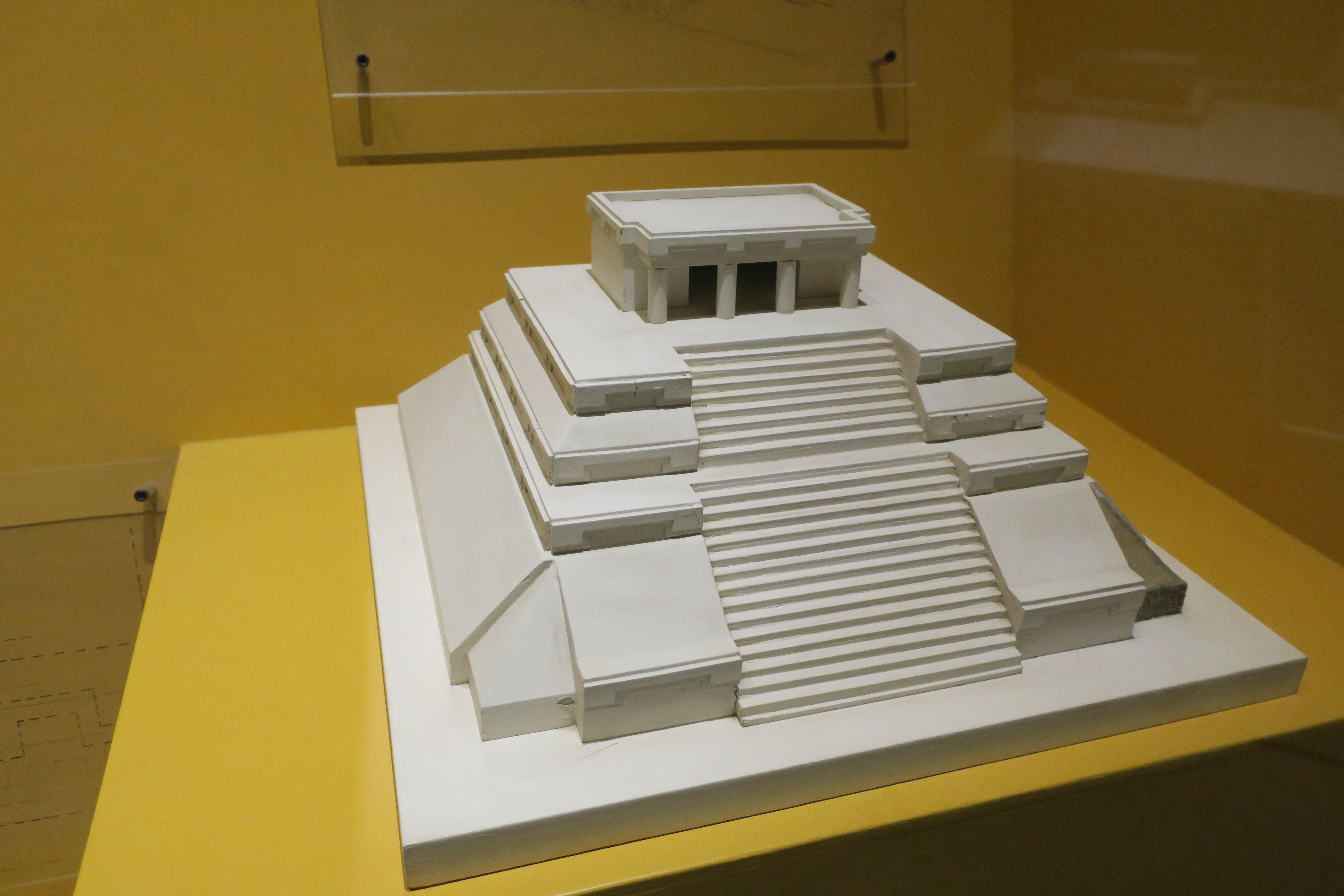
Reconstruction of a temple.
|
|
Woman with jaguar helmet.
Found in 1995, near the road that gives access to Monte Alban.
-
This piece is the central element of Tomb 214. Due to its
characteristics, it belongs to the IIIA era of Monte Alban, 300 - 600
AD.
|
|
Presentation.
A ceramic vase depicting a face with a protruding tongue (center).
|
|
Mythical tetrapod urn.
Representation of the deity of Cocijo on the lid and the Lizard on the
box. It has four hollow cylindrical supports, in general it presents a
quadrangular body with a rectangular base and straight walls, it shows
four cylindrical protrusions in the corners or vertices, as
applications.
|
|
Presentation.
A ceramic funerary urn representing Cocijo, the Zapotec god of rain and
lightning (center).
|
|
Presentation.
A ceramic funerary urn representing Cocijo, the Zapotec god of rain and
lightning.
|
|
Bat god.
Pottery depicting the bat god (right).
|
See also
Sources
Location