Cacaxtla is an archaeological site located near the southern border of the
Mexican state of Tlaxcala. It was a sprawling palace containing vibrantly
colored murals painted in unmistakable Maya style. The nearby site of
Xochitecatl was a more public ceremonial complex associated with Cacaxtla.
Cacaxtla and Xochitecatl prospered 650-900 CE, probably controlling important
trade routes through the region with an enclave population of no more than
10,000 people.
Cacaxtla was the capital of region inhabited by the Olmeca-Xicalanca people.
The Olmeca-Xicalanca are assumed to come from the Gulf coast region, and were
perhaps Maya settlers who arrived in this part of central Mexico around 400
CE.
After the fall of the nearby city Cholula (ca. 650 - 750) — in which the
Cacaxtlecas might have been involved — Cacaxtla became the hegemonic power in
this part of the Tlaxcala–Puebla valley. Warriors from Cacaxtla appear to have
taken over Cholula for a time, but they were ultimately expelled by the
Toltecs. Its ascendancy came to an end around 900 CE and, by 1000, the city
had been abandoned.
|
Entering the archaeological site of Cacaxtla.
The site is only open between Wednesday and Sunday, from 10 am to 5 pm.
Last entry is at 4 pm.
|
|
Map of Tlaxcala.
Tlaxcala, officially the Free and Sovereign State of Tlaxcala (Spanish:
Estado Libre y Soberano de Tlaxcala), is one of the 32 states
which comprise the Federal Entities of Mexico. It is divided into 60
municipalities and the capital city is Tlaxcala City.
-
It is located in east-central Mexico, in the altiplano region, with
the eastern portion dominated by the Sierra Madre Oriental. It is
bordered by the states of Puebla to the north, east and south, México
to the west and Hidalgo to the northwest. It is the smallest state of
the republic, accounting for only 0.2% of the country's territory.
-
The state is named after its capital, Tlaxcala, which was also the
name of the Pre-Columbian city and culture.
-
The Tlaxcalans allied themselves with the Spanish to defeat the
Aztecs, with concessions from the Spanish that allowed the territory
to remain mostly intact throughout 300 years of colonial period.
-
See more at
Tlaxcala - Wikipedia.
|
|
Map of Cacaxtla Xochitécatl.
Cacaxtla is in the center of the map and Xochitécatl is on the left
(west) side.
|
|
Xochitécatl Pyramid of Flowers (far).
As we walk north towards the Great Plinth of Cacaxtla, in the distance,
on the left (west), we can see the Pyramid of Flowers of Xochitécatl.
-
The Pyramid of Flowers (Pirámide de las Flores) was built
during the Preclassic Period but shows evidence of use right up to the
Spanish Colonial Period.
-
The base of the pyramid measures 100 meters by 140 meters, a similar
size to that of the Pyramid of the Moon in Teotihuacan.
-
Inside were found the burials of more than 30 children and one adult
accompanied by offerings. Beads of green stone were deposited in the
mouths of some of the children in order to accompany them on their
journey to the underworld.
|
|
Great Plinth.
The centre of the city of Cacaxtla was the 200-metre-long, 25-metre-high
Gran Basamento (Great Plinth) – a natural platform offering a
fine defensive position and commanding views over the surrounding
terrain.
-
The city's main religious and civil buildings were located on this
platform, as were the residences of the priest class.
-
Several other smaller pyramids and temple bases stand in the vicinity
of the main platform.
|
|
Cacaxtla roof.
Xochitécatl is a demonym that means the inhabitant or the native of
Xochitlan, while another translation could be “Place of the Lineage of
Flowers”.
-
Cacaxtla is derived from the word Cacaxtli, which literally means
"Place of Cacaxtles", these being indigenous frames used to transport
products.
-
In the 1980s, an enormous roof, spanning more than 100,000 square
feet, was erected over the most important section of the Great Plinth
in order to provide protection from the elements.
|
|
Blandine Gautier introduces us to Cacaxtla.
The path we are going to take on the platform is shown in this plan.
|
|
Going up to the platform.
|
|
Climbing even higher to the Palace.
|
|
Building D (right), North Square (left) and Battle Mural
(background).
|
|
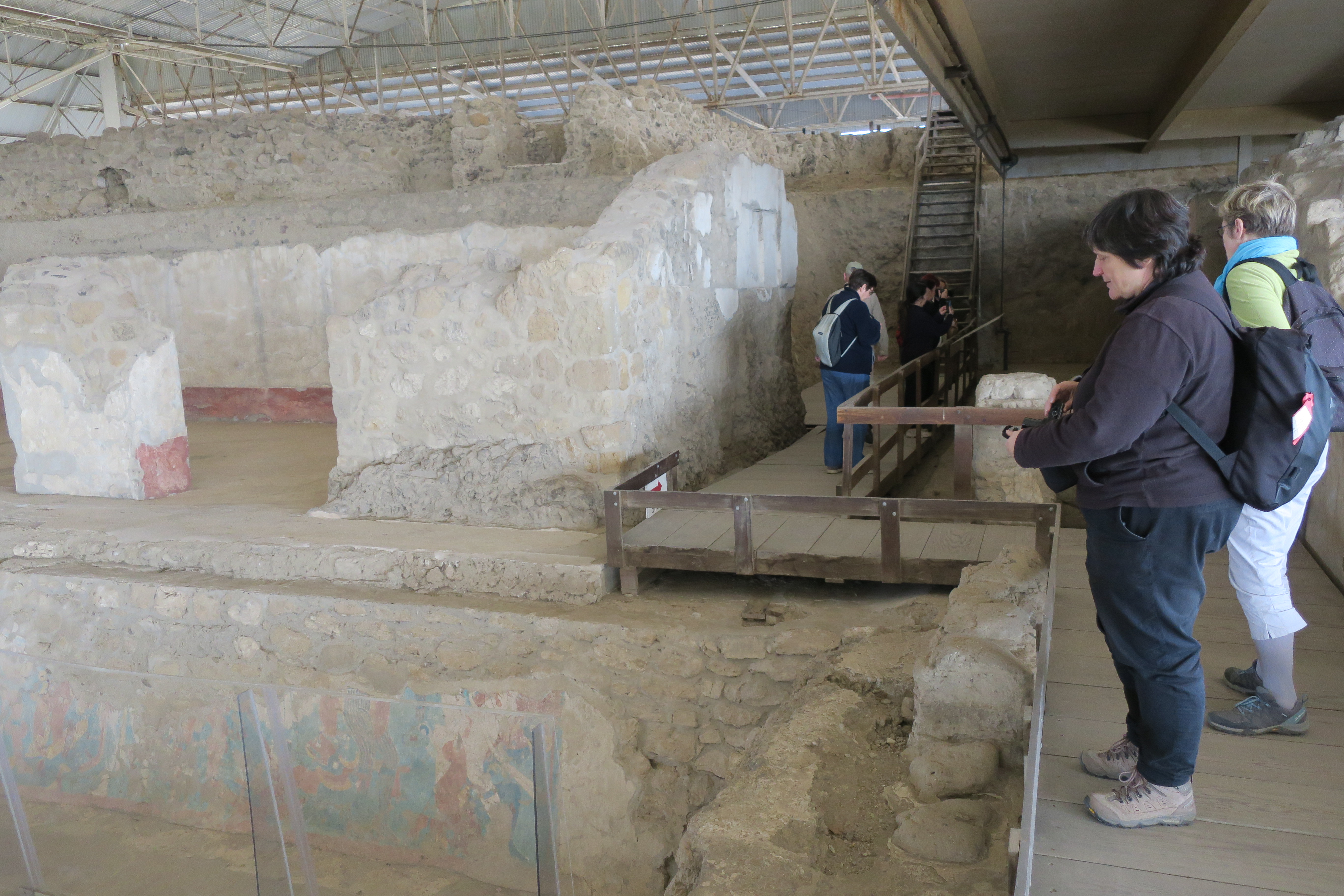
Palace view.
View of the Palace from north to south.
|
|
Palace view.
View of the Palace with the stairs to go up to the Venus Temple on the
right.
|
|
Palace view.
View of the Palace from south to north. The Battle Mural is in the
background.
|
|
Going up to the Venus Temple.
Going up the stairs that lead from the Palace to the Venus Temple.
|
|
Approaching the Venus Temple.
Going up a little more to reach the Venus Temple.
|
|
Venus Temple.
The Venus Temple that is also located underneath the roof contains two
murals on two columns of two figures.
-
On the right column, there is a male figure with a mask covering his
face. He wears a skirt with the Venus symbol on the front and has a
scorpion tail.
-
On the left, a fragment of the other figure is visible, probably
representing a woman with a skirt also bearing a Venus symbol.
-
The presence of Venus on the garments of the figures and their
representation around both of them indicate that the murals allude to
some astronomical phenomenon or calendrical data associated with the
planet Venus, which at that time was related to warfare and sacrifice.
|
|
Information panel in front of the Venus Temple.
|
|
Information panel in front of the Red Temple.
|
|
Red Temple Mural.
The Red Temple Mural (Mural del Templo Rojo) is located at the
Governors' Room (Las Habitactiones de los Gobernantes).
-
The Red Temple Mural is located in the staircase leading to the room,
and only one side is visible to the public. The other side of the
staircase is not facing a public walkway, but is displayed as a
reproduction in the corresponding museum building.
-
The lower portions of the eastern wall show a period of triumph for
the lord of the underworld in his subterranean domain. He possessed
the magical cacao tree which is the source of monetary wealth, which
is consistent with his patronage of trade. Because of all the imagery
of the maize god fused with cacao, we have good reason to think that
the tree constitutes a form of the maize god within this context.
-
The ascending staircase of the Red Temple becomes an instrument of
narrative, allowing the audience to ascend from the dark underworld to
the light and abundance of the earth's surface. Through time and
space, we follow the divine spirit of corn through the seasons. The
feathered serpent and the ascending aquatic band establish the
necessary conditions for new life: air and water that symbolically
emerge from the depths of the caverns and fountains.
|
|
Towards the Celosía.
Descending from the Red Temple towards the Celosía (Lattice). The
North Plaza is on the right (east) and the Battle Mural is in the
background (north).
|
|
The Celosía.
The Celosía is a unique architectural element of its kind in
Mesoamerica. It was built with a structure of branches covered with mud
to give it shape, to which a coating of lime and sand was applied.
|
|
Xochitécatl Pyramid of Flowers (far).
The Xochitécatl Pyramid of Flowers seen from inside the Great Plinth.
View from east to west.
-
Xochitecatl lies 1 km west of, and within sight of, the contemporary
Classic Period site of Cacaxtla.
-
About 950 AD both Xochitecatl and Cacaxtla were abandoned, although
there is evidence of continued ritual activity in the Postclassic
Period.
|
|
Building E (left) and North Plaza (right).
|
|
Decoration detail of Building E.
In it, a character can be seen framed by a band of aquatic animals,
dressed with bird elements in the headdress, shoulders and arms, as well
as claws on the feet.
-
He holds in his arms a bar of snakes, characteristic for the same
period in the central Maya area.
-
The character is standing on a feathered, bearded serpent, which
carries two elongated nose rings and a scroll next to them.
-
To the left is a macaw. Below is a numeral: a bar and dots with a
feather.
|
|
Cacaxtla Battle Mural.
The most famous of Cacaxtla's preserved paintings is the "Battle Mural",
or Mural de la batalla, located in the northern plaza of the
Great Plinth. Dating from prior to 700, it is placed on the sloping
limestone wall of a temple base and is split in two by a central
staircase.
-
It presents a narrative scene nearly 26 meters (80 feet) long about
the fearful armed fight between two clearly differentiated ethnic
groups.
-
The winning group has grayish-brown skin, a big nose, and no cranial
deformation; they are armed with round shields, obsidian knives, dart
launchers (atlatls), and spears.
-
The defeated, by their facial profiles and the deformation of their
heads, have been identified as Maya. They appear naked and wear only
plumes, pectoral vests, earplugs, and some jade jewels.
|
|
West (left) Cacaxtla Battle Mural.
|
|
Far West (far left) Cacaxtla Battle Mural.
|
|
Midle West (midle left) Cacaxtla Battle Mural.
|
|
Near West (near left) Cacaxtla Battle Mural.
|
|
East (right) Cacaxtla Battle Mural.
|
|
Near East (near righ) Cacaxtla Battle Mural.
|
|
Midle East Left (left midle left) Cacaxtla Battle Mural.
|
|
Midle East Right (right midle left) Cacaxtla Battle Mural.
|
|
Far West (far left) Cacaxtla Battle Mural.
|
|
Towards the Bird Man and Feline Man Murals.
Walking from the Battle Mural to the Bird Man and Feline Man Murals.
|
|
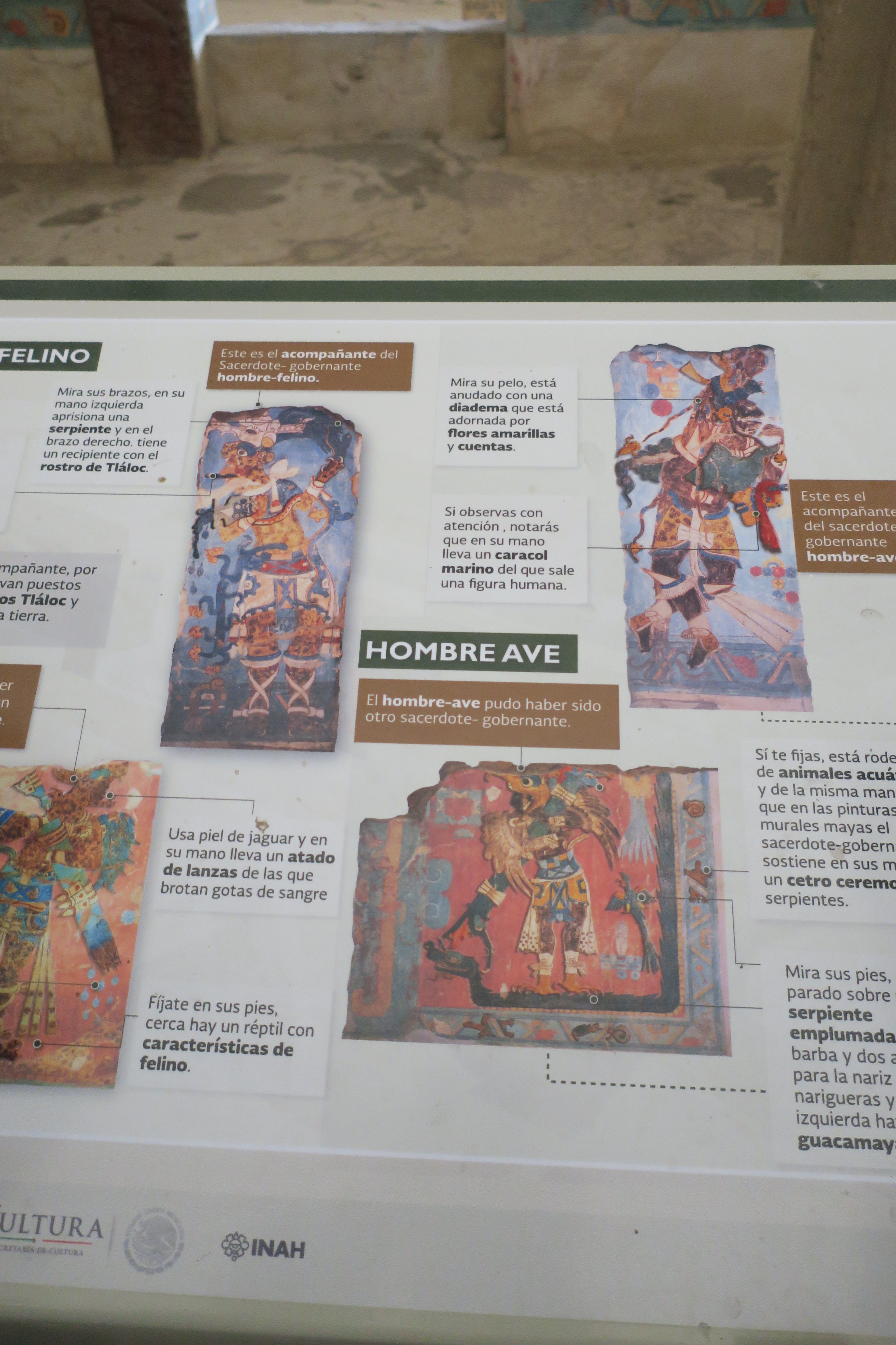
Information panel on the Bird Man Mural.
The bird man is associated with Quetzalcoatl, the generous deity who
taught people the arts and agriculture.
|
|
Information panel on the Feline Man Mural.
The feline man is associated with the rains that fertilize the earth.
|
|
The Courtyard of the Altars
The Courtyard of the Altars (Patio de los Altares) is so named
because of the existence of two altars in its centre.
|
|
Leaving the Great Plinth.
View from south to north.
|
|
Small pyramid.
Small pyramid east of the Great Plinth.
-
Several other smaller pyramids and temple bases stand in the vicinity
of the main platform.
|
See also
Sources
Location